Google Earth - A "Threat" to Indian Security???
The front page of The Time of India screams “Google Earth Exposes IAF Bases”. The article goes in length to explain, that after acquiring satellite images of the three Indian cities, viz Bangalore, Delhi and Mumbai, our national security is at risk.
The article said how one could use Google Earth, zoom in on Bangalore and view the airport, Yelahanka Air Base and HAL factory. It said that our fighter planes and helicopters are clearly visible, along with their camouflaged hangers.
Then the article speaks as to how one can zoom into Delhi, our national capital and see the Rashtrapati Bhavan or the Palam Airport. Moving over to Mumbai, the news article claimed that one could zoom into the port and see various naval ships. It claimed that INS Virat could be viewed clearly.
So according to The Times of India, the Indian national security is at risk, due to these satellite pictures.
After reading the article, the first thought was that if such things are possible with Indian cities, then it should be true for other cities as well. I was shocked to read in the paper, that US Government had blacked out the photographs of White House, so the first thing I did was to check it. I found that the claim was false.
The White House was seen with better resolution that The Rashtrapati Bhavan, all the lawns, trees, the fountain in front of the building, everything was seen clearly.
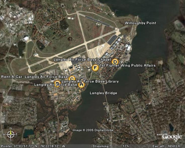
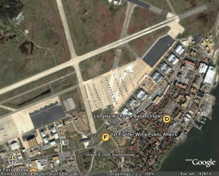
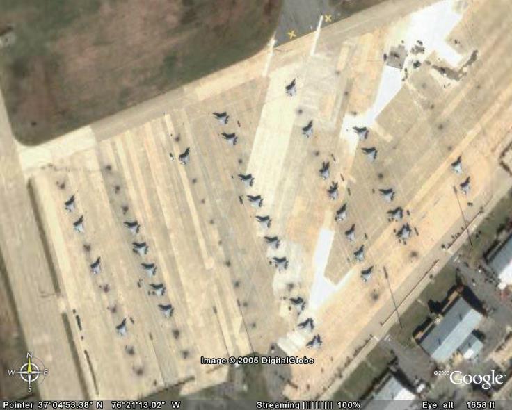
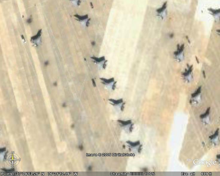
To prove that the report by The Times of India is nothing but a false rumor, I searched for Langley Air Base, one of the oldest and important Air Bases in the US. The images that I got are as shown below.

It’s a shame that a newspaper like The Times of India, choose to publish such an article. This was never expected from a paper which is more than a hundred years old and is the number one news paper in many cities. What did the paper think would happen if Google published such images? Our enemies would use it to strike us?
Our enemies which has the capability to strike us already have every square inch of the country mapped using spy satellites, others would have got the required information from such countries. They would have better images of the facilities than the ones given by Google.
I am wondering what the editors were doing. Did they find this news so disturbing that they had to put it in the front pages of their publications? If the US or any other country had no problem in such photographs being shown on Google Earth, then why should India have any issues?
posted by Arun R @ 2:37 PM
10 comments
![]()

10 Comments:
And you thought that tabloid will have brains of its own??...Never ever in my life had I loathed to read such a paper- utter trash...BTW, that story in TOI(if that had been- I hadnt read it..nor will I ever read it), shd have been "inspired"(U know the meaning- dont u:P) by this http://www.theregister.co.uk/2005/09/13/google_earth_threatens_democracy/
This came long back!..Check that out!
Arun, you should've probably realised that the first thing on the minds of these media people is "sensationalism" more than being informative and giving the news as is without any "added flavours". ToI has long time since started adopting this strategy. Best thing would be to treat such news as a joke and laugh it off or, as you did, investigate! That would probably give us more insight!! Good Post indeed Arun. Thanks for bringing this out in your blog.
An interesting thing I find on blogs these days is the term "TOI Alert". Like spoiler alert, bloggers warn the readers that the link heads over to the rag of a paper called TOI :)
@ Krish:
Read that article. these alligations makes sense only if you have something to hide. And things that are suppossed to be extra sensitive are always hidden, no matter what country.
I dont mind North Korea shouting about the satellite images of its cities, coz of the latest row with US, but other countries and India shouting regarding it is absurd.
@ Ravi:
I have had a personal experience regarding the so called "sensational news". A very unfortunate and unforgettable incident was reported in our own "Malayala Manorama". They reported then entire incident incorrectly, adding a lot of "masala". From then on I look at a news report with a lot of speculation.
@ OMR:
Oops!!! I forgot to add that warning!!!
Shall do that from the next time onwards. TOI is creating a lot of impression as a masala newspaper rather than one which reports facts.
But I think these important spots (in any country) should not be revealed through such a program.
We don't have to think if US allows it, then it is okay for us too.
@ Jo:
I think you can compare US and India with this regard. India has just 4 cities mapped in Google Earth, while in US, the entire country is mapped.
If u have Google Earth, just type Area 51, you are taken to the so called hush-hush place in the US. Area 51 is a highly sensitive military point for the US, where a lot of clandestine work goes on.
Type Air Force One, and you will be taken to the airport near the white house, where you can even see the hangers.
For a country, which boasts of the maximum number of missiles, fighter planes, wasships, submarines, namely the US, is not concerned about the photographs, then it means that the enemy, if at all there is any, cannot gain much from the satellite pictures.
All the details of the locality are already available to the person who wants it. They just need to send a person, who will go around the place and offer the so called "sensitive" details are revealed by Google Earth.
sensationalism is the keyword here i think.
the TOI ppl may also have been alarmed by ease with which terrorists can operate once they get such detailed satellite pics.
@ Poison:
Somehow I am not able to accept that the photos from Google Earth would give a potential terrorist, more information than what is available to them.
Without providing any support to Times. I think what the article tries to highlight is that such information which may have been limited to those with access to spy satellites is now available on your home pc in simple 1-2-3. That's all! And if not for terrorist attack I think providing a good road map of other secured areas does pose a security threat to a certain extent.
@ Kapil:
Don't u think the Eicher maps would be a better thing to consult than Google Earth?
They are cheaper and give u precisely the same info, except for the position of the airplanes and warships.
Post a Comment
<< Home